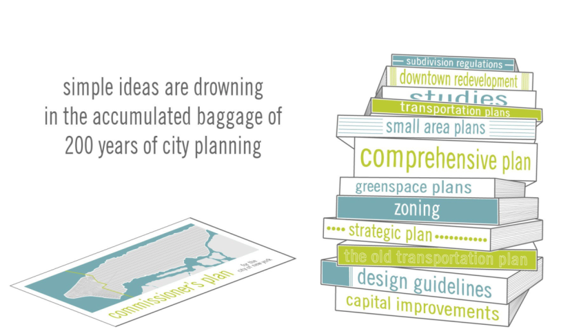
Master Street Plans
There is no great city in the world that isn’t made up of a highly connected network of streets. In fact this is the first thing that all great cities have in common: New York, London, Sydney, San Francisco, Chicago, Paris, Berlin, Barcelona, Beirut, Istanbul and on and on. In every case, whether planned (Philadelphia, for example) or more randomly grown (Paris, for example, Haussmann notwithstanding) the first element of the city is the street network.  It is the thing that creates both a physical and political framework for everything that happens in cities. It simultaneously gives form to our political structure (the physical manifestation of our collective society) and our cultural lives, allowing for all sorts of various and richly diverse developments, whether the corner deli or the Empire State Building. This isn’t really an arguable point.
Yet for some reason this thing, the projection and creation of streets, is also the single thing that is summarily discounted in virtually all planning of cities today. It is a universal refrain that compact street development can’t be implemented because it is:
- illegal – and yes this is all too true in most places in the world, but it needn’t be so
- expensive – which is statistically incorrect, a highly connected street network is the most cost-efficient system for development in both the long and short term, for both the private and public sectors
- inflexible – which is exactly the opposite (although counterintuitive) of the reality of flexible, or adaptable, urban plans
- inefficient – this is generally about traffic engineering, but in reality the connected street system is a far better capacity builder than the disconnected arterial, collector, local system
For almost 25 years I have been espousing the value and benefit of a connected street network with small blocks as the default for the way we should be designing cities, and in those years the connected street has consistently been the idea that is the most difficult for people (all people, from neighborhood groups to academics and municipal planners) to accept. I find this incomprehensible because at the same time the vast majority of people say streets are bad, or impossible to plan, they also clearly, and virtually without exception, say the best places to live and work in cities are those that are walkable, connected, rich in diversity, etc. But somehow there is a conceptual disconnect between what people want and how they act.
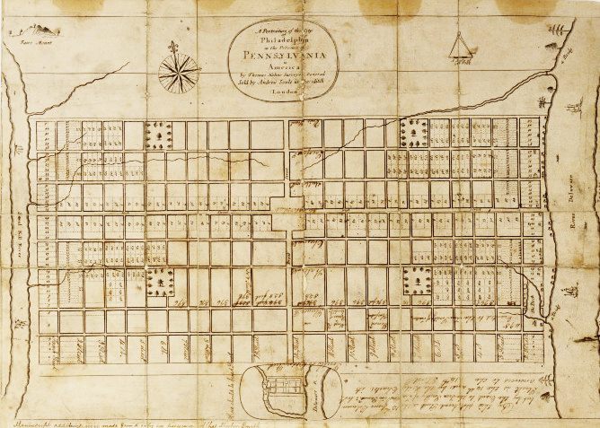
The Street Plan – the only planning device needed in 1811 and the only planning device not needed (or allowed) in 2011.
Much of this has to do with the transformation from the late 1920’s through today of the regulations that dictate how we design and plan cities. The idea that streets aren’t the prima
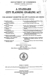
ry element of cities was precipitated by the adoption of the 1926 State Zoning Enabling Act, which described a process through which cities would be planned based on projected uses (the least permanent part of a city coincidentally), and the suppression of the 1928 City Planning Enabling Act, which simply codified a process for designing cities (starting with a master plan, which at the time was a simple projection of public rights-of-way).

Through a peculiar chronology of publication, and the 1926 Euclid v. Ambler case, the United States embarked on an 80 year effort to eradicate the conventional historic process of designing cities (beginning with Miletus 2500 year ago, and continuing until the early twentieth century) by drawing streets. Nobody at the time could have known the implications of these proceedings, although the Justice writing for the majority on the Euclid case, Justice Sutherland, understood.
And you take this through the decades of codification, the 1950’s when streets started to be defined as place for cars (and actually became roads instead of streets), and block size was based on use and, essentially, truck movements to deliver goods, and of course parking. And it was further imprinted on the collective psyche of the emerging suburban culture with seemingly simple directives such as, local street shall be so laid out that their use by through traffic shall be discouraged. Who could argue with that?

In any discussion about cities today I ask, rhetorically, why wouldn’t you design every project in every city (and every suburb) with a tightly connected street system and small blocks. And the answers, almost gut reactions, are why this is such a bad idea (see list above), none of which is true, of course. Streets are the greatest places in the world. Shouldn’t we be thinking of cities the other way around, only building disconnected, use-separated, unwalkable, buffered environments when there is no other option? And, by the way, there is never, ever no other option.